

The question of how the growth of Kerala's cities is to be planned was part of the discussions at the National Seminar on Spatial Technologies for Land Use Planning in Trivandrum the other day. The Governor of Kerala called for vertical growth to make the best use of scarce urban land. His view was one side of a major discussion - the debate over vertical versus horizontal growth in urban planning - which has been raging in cities across the world for a very long time now. Various theories and models have been developed to explained the various growth mechanisms of urban areas. In many cases, the pattern of growth is often a product of geography or of the socio-economic evolution of the particular urban area, as is the case with many natural systems. The jury is still out on as to which model is the best for the citizens or even as to whether the different models can be or need to be compared.
Before even starting to ponder how our own city can be developed, we need to understand at least an outline of the interesting and increasingly complex subject of Urban Structure. According to that all encompassing compendium of our times, Wikipedia, “Urban structure is the arrangement of land use in urban areas. Urban structure can also refer to the urban spatial structure, which concerns the arrangement of public and private space in cities and the degree of connectivity and accessibility.”
In plain-speak, urban structure is an understanding of which parts of a city are located where – are all the offices located together, are they homes located according to economic status and so on. Urban planners, sociologists, economists and geographers broadly agree on three structural models:
• Concentric Ring Model
• Sectoral Model
• Multiple Nuclei Model
The Concentric Ring Model
When a city has a high-density Central Business District surrounded by decreasing zones of development density, the urban agglomeration is said to be distributed as concentric rings. This form of urban development is seen in cities like New York or Chicago or Mumbai, to a lesser extent.
When a city has a high-density Central Business District surrounded by decreasing zones of development density, the urban agglomeration is said to be distributed as concentric rings. This form of urban development is seen in cities like New York or Chicago or Mumbai, to a lesser extent.

Conceptual view of the Concentric Ring model (Courtsey: Wikipedia)
(Inside-->Out) - CBD, Factory Zone, Zone of Transistion, Working Class Zone, Residential, Commuter)
The CBD usually has, as it name implies, most of the business space in the urban area along with some residential areas. The cost of space is usually very high due to the limited space and the high demand. However, while up-market residential and business space is very expensive, many inner cities of this type also have run-down areas inhabited by the less well-off among its citizens. These could be the older parts of the city centre where the dilapidated buildings find few high-income takers or where the transportation network is poorly developed. These areas usually spiral downwards unless revived with comprehensive redevelopment schemes.

The Bid-Rent curve (Courtsey: Wikipedia)
Immediately outside the CBD lie mid-rise districts with a predominantly residential nature. The residents are mostly middle-class and this middle ring is usually well linked to the city centre through public transport.
Finally, there are the suburbs which lie farthest for the centre of the ring city. These are almost exclusively low-rise, usually detached houses which are inhabited by the upper and middle classes. The suburbia, familiar to us in innumerable movies, is far removed from the hustle and bustle of the city centre but necessitates a long in-and-out trip everyday, the famous “commute”.
The concentric ring model may sound very convenient, and indeed, anyone not too kindly disposed towards social equality may see it as a great way to keep the masses down. Other than the fact that it creates and encourages social inequity, the concentric ring structure also imposes other difficulties like inefficiencies in transport. That may sound counter-intuitive, after all isn’t simple for everyone to travel in and out of a single focal point? But, what if the Airport is on the other side of the CBD? It means either a long, frustrating trip through the chaos of the inner city or a even longer detour along a ring road, if one fortunately exists.
The congestion at the city centre usually means very tall buildings and expensive real estate. Even if an alternate or parallel CBD was proposed, organisations may be reluctant to leave the existing centre of activity and such a shift would also require a massive change in the supporting infrastructure which would be focused on the existing CBD.
The Sectoral Model
This structure looks very much like the typical pie diagram that one sees a lot in presentations and textbooks. The urban area is divided into often well demarcated areas arranged around a common centre, where the land uses varies from sector to sector. So, one sector may be dedicated to industrial manufacture, another to high-rise residential and a third to mid-rises. Such structure can be seen in cities like Calgary, Canada.
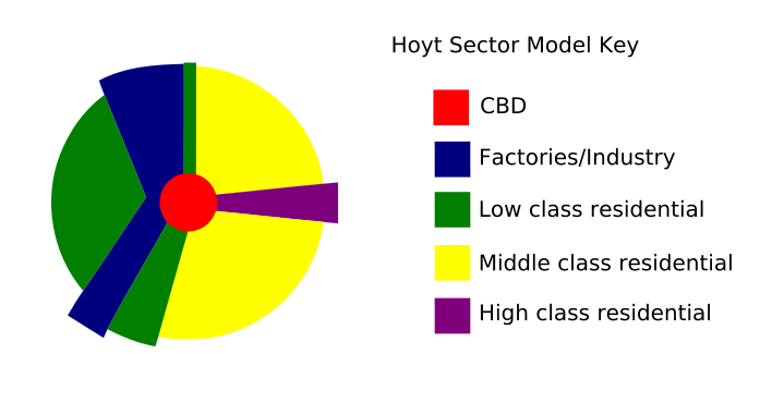
The Sectoral model enables easy expansion of the city outwards as long as radial space is available and is not constrained by some natural barrier like a water-body. However, conflicts of interest between adjacent zones of different types – say heavy industry and residential – is not uncommon. Sectors may not be planned as such, and may develop over time due to a variety of factors. A natural harbour could develop into a commercial and entertainment zone (around a marina, perhaps) or into a industrial zone. The repercussions on a neighbouring residential zone are obviously radically different.
Having different sectors scattered all over the place also makes the transportation solution a very complex one. Different routes may need to be developed for routing people and cargo, for example.
The Multiple Nuclei Model
No, I have not deviated into zoology. Rest assured, the multiple nuclei model is yet another form that a city can take, even if it sounds like something that got left behind when the little green men left after their picnic. As its name implies, this model describes urban areas which have more than one centre. There are two or more centres of activity surround by areas of residential or mixed use.
Multiple nuclei can evolve over time from the concentric ring structure, for example. You must think I am off my rocker, when I say cities evolve. Surely, evolution is the property of living things, as Mr. Darwin said. Well, cities are living too, aren’t they? In a way, urban environments are complex ecosystems populated by millions of intelligent constituents, including you and me. Like any dynamic system, cities too can evolve. In fact, far from being a property only of living things, elements of evolution can be seen in any system in which there is change and competition.
Multiple nuclei can evolve when a city develops new centres as its original one gets too congested. Look at Mumbai, for example. Once, South Mumbai with Nariman Point and its skyscrapers as its focus, was the island city’s only CBD. Over time, as this centre became impossibly congested, new business districts have evolved, most notable in Bandra-Kurla and in Navi Mumbai. The same is the case with Gurgaon and Noida in the case of New Delhi. These nuclei may each have residential districts develop around them as people try to minimise the commute to their respective work places. While the new nuclei may give the city more scope to expand, it is not without its own ails.
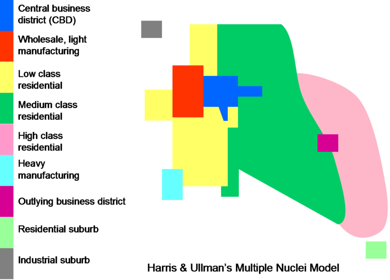
Each nucleus and its surrounding areas may not be totally self-contained. In Bangalore, for instance, there are multiple business hubs – Electronics City, Whitefield, Airport Road, Outer Ring Road etc – but most of the social infrastructure lies in a few areas mostly in South Bangalore, which leads to very heavy commuting and its associated chaos.
Multiple nuclei almost invariably require high-volume transportation systems like Mass Rapid Transit Systems (MRTS) which are very expensive but are indispensable to move hundreds of thousands of people quickly, safely and comfortably. High speed linkages also need to be put in place to allow access to common infrastructure points like the city’s airport(s) or railway station(s) from all the nuclei. Strong urban planning is also called for to ensure that mixed-use development surrounds each nucleus, reducing the need for long commutes.
(Thus ends Part I. Part II, talking about how all of this applies to Trivandrum, is ready and will be up in a few days, once everyone has a chance to wade through this one. Stay tuned and thanks for your patience.)


0 comments:
Posting Komentar